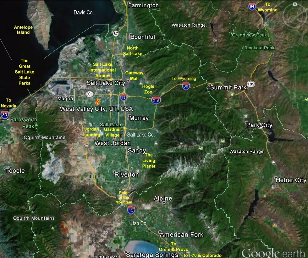
Places to Go, See & Do - around the Salt Lake Valley
Map Updated 2 Oct 2019
The Jordan River Parkway - Legacy Parkway Trails = 55+ miles one way
Salt Lake Valley Mountain Peaks
Webcams:>> Weather | Ski Resort | North Salt Lake | Salt Lake City | Salt Lake Valley
Webcams:>> Utah Travel | Utah Weather | World Cams | U.S. State Maps
Video >> Ogden Balloon Festival in Eden UT
Links Open in New Tab/Window
-
The Great Salt Lake - 75 miles long x 35 miles wide - 41°10′N 112°35′W
-
Salt Lake City 95 Parks & Lands Interactive Map
-
Salt Lake City - Geographic information, applications, and maps
-
Salt Lake County - Geographic Information Systems Maps
-
Antelope Island - free-ranging bison, mule deer, bighorn sheep, pronghorn (antelope), and many other desert animals. An area of 42 square miles, the largest of 10 islands located within the Great Salt Lake
-
Great Salt Lake Shorelands Preserve - World-Renowned Migratory Bird Habitat - Protecting one of the western hemisphere's most important stopovers for migrating birds. - 36 miles from WVC
-
SLC International Airport - 1911 originally used for aerobatic flights and was the site of the "Great International Aviation Carnival."
-
The Gateway Outdoor Mall - over 105 stores and restaurants - 40°46′07″N 111°54′14″W / 40.7685°N 111.9038°W
-
The Hogle Zoo - Opened 1931 - 42 acres - 40°44′59″N 111°48′50″W / 40.7498°N 111.814°W
-
This is the Place Heritage Park - opening day 24 Jul 1847
-
Jordan Landing - 1,400,000 square feet of retail space, located in West Jordan - 40°37′N 111°59′W
-
Gardner Village - established in 1850 - 40°36'33.55 N 111°55'24.16 W
-
Downtown Farmers Market, Pioneer Park on 300 South 300 West. Saturday from June 11 through Oct. 22, from 8 a.m. to 1 p.m.
-
The Living Planet Aquarium - holds 1250 animals and 267 species in three main exhibits
-
Lagoon Amusement Park - opened in 1886 - 53 rides and ten roller coasters, five of which are unique: Late March – October
-
Connection to Legacy Parkway Trail is 14 miles long
-
Point of the Mountain - World Famous Paragliding Location Expert Gliders Teach All Year Round
Expert Gliders Teach All Year Round -
West Valley Family Fitness Center - Located in Centennial Park, 96,000 square-foot Center is one of the Salt Lake valley’s premier fitness facilities. Which has a lap pool, a leisure pool with the state’s tallest indoor waterslide, basketball and racquetball courts, an indoor track, cardio equipment, a weight room, a climbing wall, dance and aerobic rooms, and a soft-play “edutainment” room for children.
-
Accord Ice Center - West Valley City UT
-
Rice-Eccles Stadium - University of Utah
-
Bicycling Routes Salt Lake Valley Map 1 - Map 2 (Wasatch Range)
-
Utah County Names & Locations
![]()
Through the middle of the Salt Lake Valley is the Jordan River Parkway & Trail, now joining Legacy Parkway adding 15 more miles of trails of urban park, open year round to Walkers, Speed Walkers, Joggers, Bicyclist, skateboarders, wheelchair's, people walking their pets and children...with numerous amenities of public parks, nature/wildlife preserves, benches, grassy areas, picnic tables, pavilions, restrooms, playgrounds, parking lots, canoe marinas, off highway vehicle (OHV) area, model plane ports, and equestrian areas can be found along the trail. The Legacy Trail is joined with the Rio Grande Rail Trail clear through Roy Utah up north. These Trails link Utah County to Salt Lake County & Davis County
mouse over on the map & click on
Antelope Island, Great Salt Lake State Parks, Salt Lake International Airport
Gateway Mall, Hogle Zoo, Gardner Village, Jordan Landing
the Living Planet, Point of the Mountain, West Valley City
|
Map Updated 2 Oct 2019 |
The Google Earth map above presents the current state of the paved sections (green) of the Jordan River Parkway Trail as of November 17, 2009 as well as existing dirt sections (brown), suitable for hiking or mountain biking and roadway connections (red) between discontinuous trail sections. Extra features such as paved parking areas and restrooms are also shown.
|
West Valley City, UT - Joseph Harker and his family were the first settlers in the territory known as "over Jordan" WVC History click name to view web page - click address to view map location |
|
|
South Plaza Center Dr. x Center Park Dr. West Jordan, UT 84084
Utah's Hogle Zoo
The Gateway
Pioneer Park on 300 South 300 West
University of Utah |
Gardner Village
Sandy, UT 84094
This is the Place Heritage Park - Petting Corral Salt Lake City, Utah 84108 |
![]()
The City-County Building sits between State Street, Second East, Fourth South, and Fifth South in Salt Lake City, a block called "Washington Square." Named for George Washington, the block is the site of the original 1847 Mormon pioneers' camp in Salt Lake City.
Like other blocks in Salt Lake City's original grid, Washington Square is 10
acres.
The Salt Lake City and County Building, alone in the center of the block, takes up relatively little space. Trees, walkways, and statues surround the building making Washington Square like a small park. Indeed, the block is often the site of fairs, concerts and other activities.
In July 1847 the first company reached the Salt Lake Valley, with scouts Erastus Snow and Orson Pratt entering the valley on July 21. Pratt wrote: ...we could not refrain from a shout of joy, which almost involuntarily escaped from our lips the moment this grand and lovely scenery was within our view. The two scouts undertook a twelve mile exploratory circuit into the valley before returning to the larger party.
The next day, larger segments of the valley were explored, streams and hot springs investigated and the first camp established in the Salt Lake Valley.
On July 23, Pratt offered a prayer dedicating the land to the Lord. Ground was broken, irrigation ditches were dug, and the first fields of potatoes and turnips were planted.
On July 24, Brigham Young first saw the valley from a “sick” wagon driven by
his friend Wilford Woodruff. According to Woodruff, Young expressed
his satisfaction in the appearance of the valley and declared "This is the
right place, drive on." Today a monument stands in the spot where he
made this declaration. Young later reported that he had seen the
valley, including Ensign Peak, in a vision and recognized the spot.
On July 28, Young established a location for the future Salt Lake Temple and
presented a city plan to the larger group for their approval.
In August 1847, Young and other selected members of the vanguard company returned to Winter Quarters. By December 1847, more than two thousand Mormons had completed the journey to the Salt Lake Valley.
I too had a vision, living in Utah one day...this came true 20 Oct 2005...D.R. "Doc" Young
![]()